Must-Do Road Trips in The Golden State to Experience this
Summer
California’s diverse landscapes are best experienced on the
open road and by the extensive rail network, where iconic journeys reveal
everything from dramatic coastlines to spectacular national parks. From
legendary routes to lesser-known byways, rich farmlands to luscious alpine
lakes, the Golden State has something to impress all tastes. Read on to
discover eight road and rail adventures to explore in California this summer.
Cruise along the newly reopened Highway 1
Start: Leggett, Mendocino County
End: Dana Point, Orange County
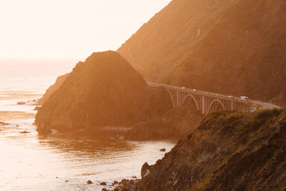
Stretching roughly 650 miles from Leggett in California’s
North Coast to Dana Point in Orange County, the full length of Highway 1 is now
fully accessible following the reopening in Big Sur. Starting in Mendocino
County, explore the region’s redwoods before heading for San Francisco over the
Golden Gate Bridge. Heading south, the route hugs the coast past Half Moon Bay
towards the dramatic cliffs of Big Sur. Spot elephant seals in San Simeon,
before heading further south through SLO CAL. Stop in the laidback coastal town
of Oxnard or the upscale coastal communities in Los Angeles before reaching
Orange County to explore gems like Huntington Beach and Dana Point - the end of
Highway 1 - for surfing and whale watching. Whether driven north to south or
vice versa, the route offers the very best of California's coastline.
Celebrate the 100-year legacy of Route 66
Start: Needles, Deserts Region
End: Santa Monica, Los Angeles County
Honour the centenary of Route 66 in 2026, spanning eight
states from Illinois to California. California is home to 314 miles of the
iconic route and holds the official end of the route in Santa Monica. Enter
California at Needles on the California-Arizona border and enjoy a pitstop at
Amboy to refuel at the mid-century modern gas station and diner, Roy’s Motel
& Café. From here, explore classic Americana in Victorville at the
California Route 66 Museum to discover memorabilia from the highway. The route
continues on via San Bernardino and then through the heart of Los Angeles.
Finish at Santa Monica Pier and be sure to snap a photo at the “End of the
Trail” sign to commemorate the historic route.
Explore epic landscapes along the Volcanic Legacy Scenic
Byway in Northern California
Start: Lassen Volcanic National Park, Shasta Cascade
End: Lava Beds National Monument, Shasta Cascade
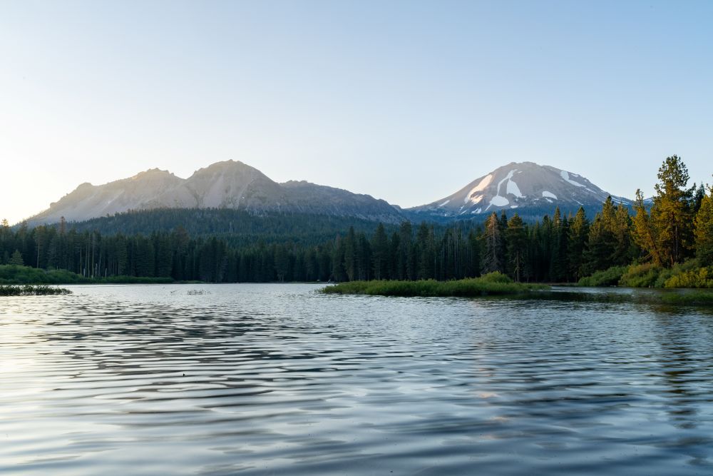
The Volcanic Legacy Scenic Byway offers striking landscapes,
starting in Lassen Volcanic National Park, one of the only places where all
four volcano types - plug dome, shield, cinder cone and composite - can be
found. Travel southbound around the edge of the National Park before reaching
Lake Almanor which offers a great trail around its shores and views of Lassen
Peak. Continue via Susanville and make a stop at Lassen Historical Museum and
Roop’s Fort for a fascinating insight into local and Native history. Journey
northbound to the scenic McCloud Falls before reaching the spectacular Mount
Shasta (over 14,000 ft). For the final part of the journey, head towards the
Oregon-California border to Lava Beds National Monument and explore the
hundreds of caves which were formed thanks to lava which flowed there half a
million years ago.
Get swept away to the ‘Rim of the World’ in the San
Bernardino Mountains
Start and end: Big Bear Lake, Inland Empire
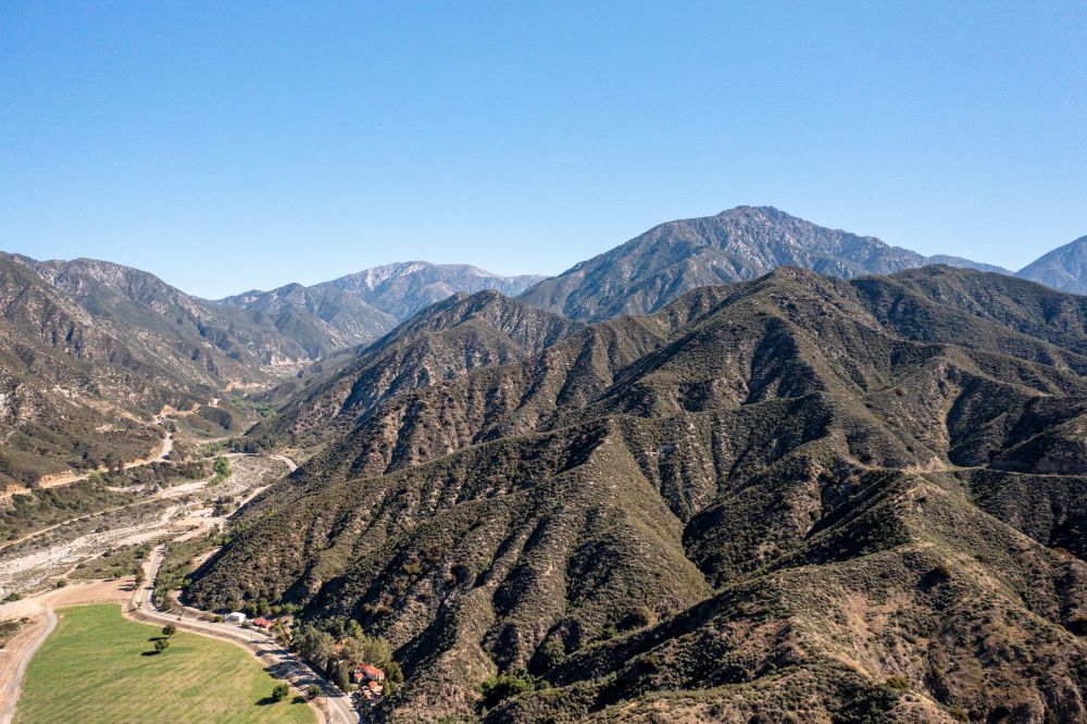
Southern California provides impressive mountain landscapes
with the 110-mile long Rim of the World Scenic Byway offering breathtaking
forest and mountainous terrain. Best explored during summer, begin at Big Bear
Lake which in itself is a great spot with watersports on the lake and plenty of
trails. Continue on Highway 18 which follows the crest of the San Bernardino
Mountains, inspiring the route’s ‘Rim of the World’ name. Take a short detour
to Keller Peak Lookout Tower to witness far-reaching views of the Inland Empire
and Catalina Island in the distance. Continue onward to Lake Arrowhead, which
connects with a section of the Pacific Crest Trail, eventually looping back to
Big Bear Lake on Highway 18.
Experience the lesser-visited side of Yosemite National Parka
Start: San Francisco, San Francisco Bay Area
End: Tuolumne Meadows, Gold Country
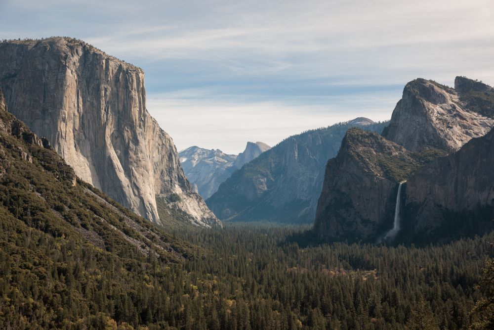
Pair San Francisco with a quieter side of Yosemite National
Park in Tuolumne County. Spend time exploring the unique neighbourhoods of San
Francisco, before heading east via Highway 120 through Manteca. Take Highway 49
- the Golden Chain Highway - for a pitstop in Jamestown, a preserved Gold Rush
town where you can still try gold panning and explore its history. Rejoin
Highway 120 into Yosemite National Park via Tioga Pass, with access to the
Tuolumne Grove of Giant Sequoias with impressive trees and far fewer crowds than other areas of the
park. Staying in Tuolumne County offers a calmer base with easy access to the
park, while also connecting you to the region’s Gold Rush past and less-visited
natural scenery.
ABOUT VISIT CALIFORNIA:
For more information about Visit California, go to visitcalifornia.com.
VISIT CALIFORNIA UK AND IRELAND MEDIA CONTACT:
Isabel Lawson, PR Account Manager at Visit California UK and Ireland,
Isabel.Lawson@visitcalifornia.co.uk
Grace Verdon, PR Account Director at Visit California UK and Ireland,
Grace.Verdon@visitcalifornia.co.uk